Congress Spotlight #74 – Computer Science Solutions to Better Understand Forest Cover and Land Use Changes in Brazil
Using 21st century technology to examine the dynamics of land use and land cover (LULC) in tropical forests over time, and how those forests are affected by the changes, will be among the subjects discussed at the IUFRO World Congress in Brazil shortly.

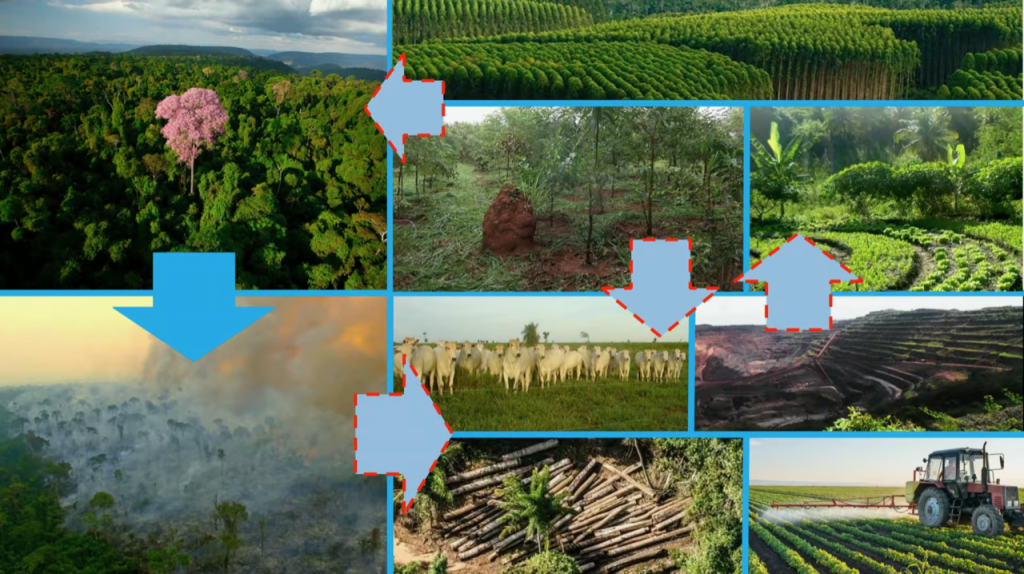
“There are a number of mapping and monitoring initiatives for forest cover, but there is still a lack of understanding of the dynamics, factors and pressures that impact forests over time in the landscape,” said Dr. Tasso Azevedo, of the Brazilian Annual Land Use and Land Cover Mapping Project (MapBiomas).
Dr. Azevedo is chair of the Congress session entitled: Cloud computing and remote sensing to understand 30-year dynamics of Brazilian forests.
“For Brazil,” Dr. Azevedo said, “a pathway to make the country a net sink of carbon in land use and in the forest sector is to continuously monitor native vegetation gain and loss, its related land use change and drivers, and to support public policies directed to guarantee proper law enforcement and sustainable management.
“To combat deforestation and degradation, we have to monitor them and, more critically, transform the monitoring results into action.
“We want to identify the drivers of land use changes and thus allow better decision making that will incentivize the positive changes such as restoration, while curtailing the negative ones such as deforestation,” he said.
At the Congress session, a series of annual land cover/land use maps and what they reveal through the passage of years in the Caatinga (northeastern Brazil), Cerrado (the savanna), Amazon and Chaco regions will be presented, as well as new technologies for monitoring and modeling land cover/use.
Presentations will also foster better understanding of native vegetation dynamics and processes such as deforestation, degradation, restoration and their impacts on climate change and sustainable production.
The data presented, in addition to assisting in the understanding of various tropical forest processes and dynamics, will also explore opportunities and challenges for global mapping.
The MapBiomas project will be a primary focus of the session. MapBiomas is described as a large-scale rapid and collaborative initiative that uses sophisticated technology to monitor the dynamics of land cover and use, and thus contribute to understanding processes that affect forest conservation.
It came about as a way to generate maps to estimate the annual greenhouse gas (GHG) emissions from land use change and forests (LUCF) in Brazil.
“LUCF is the main source of GHG in Brazil and since no land cover/use annual maps were available on an annual basis, emissions estimates were based on gross deforestation data as a proxy,” said Dr. Julia Shimbo, the Scientific Coordinator of the project.
The MapBiomas project began in Brazil three years ago. It provides free annual land cover and land use maps of the country from 1985-2018 on an interactive platform.
The web-platform allows the exploration of land cover/use and land use changes using annual data, maps and statistics. It also looks at aspects related to territory, such as biome, state, municipality, watershed, indigenous lands, protected areas, private properties and by infrastructure buffers such as roads and power lines.
All MapBiomas products, as well as the tools and methods to produce the maps, are available at no cost on the internet.
“The goal,” said Dr. Shimbo, “is to contribute to making the land use sector in Brazil a net sink of GHG with zero deforestation, and to promote both large-scale regeneration of forest and natural habitats and sustainable management of land use activities.
“The MapBiomas data is being used by a variety of decision makers and by civil society to generate information for assessment, planning and decision making to combat and reduce illegal deforestation, understand its drivers, and build conservation strategies for future emission reductions and mitigation,” she said.
It has also expanded into other Amazonian countries – Peru, Ecuador, Bolivia, Colombia, Venezuela, the Guyanas and Suriname – and the Chaco region (Argentina, Bolivia and Paraguay) and will be going to Uruguay and Indonesia.
“The expansion to other countries has been successful with local institutions, but qualified development teams to map and understand land cover and land use change still need training and support,” Dr. Shimbo said.
“At this Congress session we will present and discuss up-to-date LULC data and applications for better understanding of those issues – deforestation, restoration, etc. – mentioned earlier, as well as the opportunities and challenges for global land cover and land use mapping to improve land use planning decisions and to prevent illegal deforestation,” Dr. Azevedo added.
See you at the IUFRO 2019 World Congress!
Visit http://iufro2019.com/ * Look out for #IUFRO2019 on Twitter and XXV IUFRO World Congress 2019 on Facebook
View all IUFRO Spotlights at http://www.iufro.org/media/iufro-spotlights/

Leave a Reply